Weather Alert in Colorado
Flood Watch issued July 17 at 12:32PM MDT until July 17 at 8:00PM MDT by NWS Pueblo CO
AREAS AFFECTED: Teller County/Rampart Range above 7500fT/Pike's Peak Between 7500 And 11000 Ft; Pikes Peak above 11000 Ft; Canon City Vicinity/Eastern Fremont County; Northern El Paso County/Monument Ridge/Rampart Range Below 7500 Ft; Colorado Springs Vicinity/Southern El Paso County/Rampart Range Below 7400 Ft; Pueblo Vicinity/Pueblo County Below 6300 Feet; Walsenburg Vicinity/Upper Huerfano River Basin Below 7500 Ft; Trinidad Vicinity/Western Las Animas County Below 7500 Ft; La Junta Vicinity/Otero County; Eastern Las Animas County
DESCRIPTION: * WHAT...Flash flooding caused by excessive rainfall is possible. * WHERE...Teller, El Paso, Eastern Fremont, Pueblo, Huerfano, Otero and Las Animas Counties. * WHEN...Until 8 PM MDT this evening. * IMPACTS...Excessive runoff may result in flooding of rivers, creeks, streams, and other low-lying and flood-prone locations. Creeks and streams may rise out of their banks. * ADDITIONAL DETAILS... - Thunderstorms containing heavy rainfall are possible across the watch area. Many of these areas have seen heavy rainfall in recent days. - http://www.weather.gov/safety/flood
INSTRUCTION: You should monitor later forecasts and be prepared to take action should Flash Flood Warnings be issued.
Want more detail? Get the Complete 7 Day and Night Detailed Forecast!
Current U.S. National Radar--Current
The Current National Weather Radar is shown below with a UTC Time (subtract 5 hours from UTC to get Eastern Time).

National Weather Forecast--Current
The Current National Weather Forecast and National Weather Map are shown below.

National Weather Forecast for Tomorrow
Tomorrow National Weather Forecast and Tomorrow National Weather Map are show below.

North America Water Vapor (Moisture)
This map shows recent moisture content over North America. Bright and colored areas show high moisture (ie, clouds); brown indicates very little moisture present; black indicates no moisture.

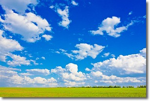
Weather Topic: What are Cumulus Clouds?
Home - Education - Cloud Types - Cumulus Clouds
 Next Topic: Drizzle
Cumulus clouds are fluffy and textured with rounded tops, and
may have flat bottoms. The border of a cumulus cloud
is clearly defined, and can have the appearance of cotton or cauliflower.
Cumulus clouds form at low altitudes (rarely above 2 km) but can grow very tall,
becoming cumulus congestus and possibly the even taller cumulonimbus clouds.
When cumulus clouds become taller, they have a greater chance of producing precipitation.
Next Topic: Drizzle
Weather Topic: What is Evaporation?
Home - Education - Precipitation - Evaporation
 Next Topic: Fog
Evaporation is the process which returns water from the earth
back to the atmosphere, and is another crucial process in the water cycle.
Evaporation is the transformation of liquid into gas, and it happens because
molecules are excited by the application of energy and turn into vapor.
In order for water to evaporate it has to be on the surface of a body of water.
Next Topic: Fog
Current conditions powered by WeatherAPI.com


