Weather Alert in Colorado
Air Quality Alert issued July 16 at 9:10AM MDT by NWS Grand Junction CO
AREAS AFFECTED: Ouray, CO; San Miguel, CO; Delta, CO; Eagle, CO; Pitkin, CO; Gunnison, CO; Mesa, CO; Montrose, CO; Garfield, CO
DESCRIPTION: The Colorado Department of Public Health and Environment has issued the following... WHAT...Air Quality Health Advisory for Wildfire Smoke. WHERE...Mesa, Garfield, Eagle, Pitkin, Lake, Delta, Gunnison, Chaffee, Montrose, San Miguel and Ouray Counties. Locations include, but are not limited to Grand Junction, Glenwood Springs, Eagle, Vail, Aspen, Leadville, Delta, Gunnison, Buena Vista, Salida, Montrose, Nucla, Telluride and Ouray. WHEN...800 AM Wednesday July 16 to 900 AM Thursday July 17 IMPACTS...Multiple wildfires will produce periods of moderate to heavy smoke across the advisory area through early Thursday morning. The heaviest smoke impacts will likely be in close proximity to the South Rim fire in eastern Montrose County, the Sowbelly Fire and Turner Gulch fires in southern Mesa County, and areas directly downwind of the Deer Creek fire in Montrose and San Miguel Counties. Thunderstorms are possible near the fires on Wednesday, and may produce gusty, erratic winds that can send smoke in any direction. HEALTH INFORMATION...Public Health Recommendations: If smoke is thick or becomes thick in your neighborhood you may want to remain indoors. This is especially true for those with heart disease, respiratory illnesses, the very young, and older adults. Consider limiting outdoor activity when moderate to heavy smoke is present. Consider relocating temporarily if smoke is present indoors and is making you ill. If visibility is less than 5 miles in smoke in your neighborhood, smoke has reached levels that are unhealthy.
INSTRUCTION: N/A
Want more detail? Get the Complete 7 Day and Night Detailed Forecast!
Current U.S. National Radar--Current
The Current National Weather Radar is shown below with a UTC Time (subtract 5 hours from UTC to get Eastern Time).

National Weather Forecast--Current
The Current National Weather Forecast and National Weather Map are shown below.

National Weather Forecast for Tomorrow
Tomorrow National Weather Forecast and Tomorrow National Weather Map are show below.

North America Water Vapor (Moisture)
This map shows recent moisture content over North America. Bright and colored areas show high moisture (ie, clouds); brown indicates very little moisture present; black indicates no moisture.

Weather Topic: What are Hole Punch Clouds?
Home - Education - Cloud Types - Hole Punch Clouds
 Next Topic: Mammatus Clouds
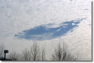
A hole punch cloud is an unusual occurrence when a disk-shaped
hole appears in a cirrostratus, cirrocumulus, or altocumulus cloud.
When part of the cloud forms ice crystals, water droplets in the surrounding area
of the cloud evaporate. The effect of this process produces a large elliptical
gap in the cloud. The hole punch cloud formation is rare, but it is not specific
to any geographic area.
Other names which have been used to describe this phenomena include fallstreak hole,
skypunch, and cloud hole.
Next Topic: Mammatus Clouds
Weather Topic: What are Nimbostratus Clouds?
Home - Education - Cloud Types - Nimbostratus Clouds
 Next Topic: Precipitation
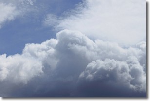
A nimbostratus cloud is similar to a stratus cloud in its formless,
smooth appearance. However, a nimbostratus cloud is darker than a stratus cloud,
because it is thicker.
Unlike a stratus cloud, a nimbostratus cloud typically brings with it the threat
of moderate to heavy precipitation. In some cases, the precipitation may evaporate
before reaching the ground, a phenomenon known as virga.
Next Topic: Precipitation
Current conditions powered by WeatherAPI.com


